Measuring play space on generated land with 21 tests
Valleys with gates, rock stacks, overlooks and a ridge lookout, laid on a test island and scored by a measure that went from 7 passes to 21.
The generator can now lay play-space features on eroded land and score whether the result is interesting to cross. On a 4 km test island called the Proving Ground, the plain build passes 7 of 21 tests and the build with features passes all 21. The features cost 3.1 points of easy ground, 61.5% down to 58.4%, and my limit was 5 points and never under 50%. The 10 km island that the game uses doesn’t have any of this yet.
Why did the island need features?
On 20 October I called the generated island accurate but featureless and dull. Stream-power erosion makes every slope correct and alike, so I wanted designed shapes laid over the physics, and a way to measure whether they worked. A knowledge base section now lists five things to build in: landmarks, valleys and passes as the routes, chokepoints between open ground, vantage points, and a pacing of beats along every route.
How does the measure work?
The measure runs after the play step and works on the least-time routes the game already finds, sampled every 50 m, plus a census of all the land. A landmark is a summit with a prominence of at least 1.5% of the world’s side, where prominence is the height over the highest col that joins it to higher ground. A top counts as seen when an eye 1.7 m up sees it over the ground between and it stands at least one degree over the line of sight.
A choke is a stretch of a route where the walkable width, measured to the first ground over 42 degrees, water or sea, is under 80 m, with ground at least 2.5 times as wide within 300 m before and after. A valley is route ground 15 m lower than the mean within 300 m, with ground 40 m higher on both sides. Along each route I count beats by run time: a reveal when a landmark’s top comes into view after 150 m hidden, a choke, a vantage within 100 m, a crest or pass, entering or leaving a valley, and water. The land is also sorted into six landform classes from a 300 m position index, and the test is the entropy of that.
Each test is a band and not a direction, because too few chokes is an open plain and too many is a maze. On top of the 21 sits a gate. Walkable ground reached on foot can’t fall, and easy ground can fall by at most 5 points.
How are the features laid?
The shaping runs inside the erosion step, before the lakes are cut, so the water is routed over the new forms. The order matters. Overlook knolls go first, because a 44 m knoll hides what stands behind it. Then rock stacks, domes and mesas, then valleys, then lookouts last, on the ground as it will be.
Knolls and rock stacks are scored candidates near the routes. The score is the land they show within 3 km, plus the route length near one, minus the easy ground it costs. I first placed them by straight lines from the start, which saw over ridges that the routes go around, and forms placed that way measured 0 to 14% seen. Now the placement routes the way the measure does. A noisy outline scaled as a share of distance tripled one ramp’s slope, and one knoll took 1.5% of the island’s easy ground. Adding the noise as meters and weighing the cost in the choice fixed that.
A valley has a floor graded through a list of heights, with the rock weakened so erosion clears it. Its walls are held, which means a floor the erosion may not cut below. They rise over a scree apron, and their height changes from 0.45 to 1.25 of the nominal wall height over about 260 m. The first version had walls of even height and they looked machined, like a row of panels. A gate is two buttresses pinching the floor to a chosen gap.
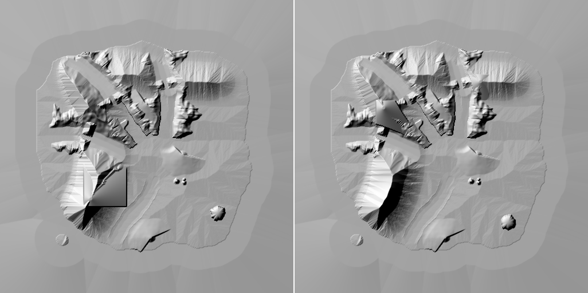
The featured island’s hillshade before (left) and after (right) the erosion change below. The flat slab on the right is a lookout’s way up.
Why does a lookout need a rim?
Once that summit counted as a discovery, the vantages together saw only 62% of the land and the test wants 70%. I added a ridge lookout: a level top on a crest, snapped to the highest ground within 60 m, with a 24 degree shoulder and a way up that raises the last 600 m of the least-time route to a 22 degree ramp. It only fills, never cuts, so no summit gets lower, and it needs 30 m of fill at most. It sits on the West Ridge’s top at 332.7 m, and the vantage test went from 0.66 to 0.77.
My first pad was 30 m wide and its view fell from 0.595 to 0.011. A level top hides every slope below a few degrees behind its own edge, so from its middle it sees almost nothing. Now the pad is 20 m, and a lookout’s view is taken from its center plus eight spots 4 m inside the rim, which is where a person would stand. From below, a levelled summit is seen by its rim, not its middle, and the measure does the same.
Why were the cliffs banded?
The walls still showed ribs in the game for two reasons. The export chose ground texture per 8 m cell, and now it chooses per 1 m vertex. The other cause was in the erosion. Its angle-of-rest bound only checked the 8 neighbors, an octagonal cone, so a face between the axes and the diagonals set into a sawtooth of facets. I added the 8 knight’s-move cells, which makes a 16-sided cone, and most of the horizontal bands went.
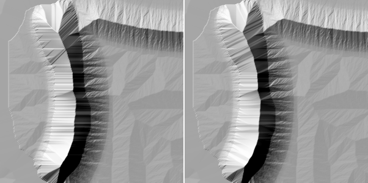
The plain island’s West Ridge before (left) and after (right) the knight’s-move bound. The horizontal bands on the left are mostly gone.
That change moved one summit across a test’s edge. It was seen from 28% of the route within 1 km but 24.4% within 3 km, against a threshold of 25%, so the landmark test flipped on a 0.6 point difference. I decided to count a summit by its 3 km share only. A summit the routes can’t see is a discovery, not a failure, and that is how the island came back to 21 of 21.
What is left?
The 10 km island needs the same pass, with its own routes, valleys and passes, measured before and after the same way. Fainter bands remain low on the West Ridge’s west face, and I haven’t judged the Saddle’s walls in the game. A lookout’s way up is also a flat slab with straight edges, visible in the picture above, and I want to fill only a strip along the route.